Drought
Drought arrives slowly and with little notice. Cistern levels start to fall, hillsides start to turn brown, the rains do not return, and what seemed like just another dry spell becomes a drought.
Drought in the U.S. Virgin Islands
• Drought takes time to develop, it takes time to resolve.
• Severe droughts are becoming more frequent.
• Early warning and prediction of drought can help mitigation.
Understanding Drought
Drought arrives slowly and with little notice. Cistern levels start to fall, hillsides start to turn brown, the rains do not return, and what seemed like just another dry spell becomes a drought.
Minor droughts in the form of the dry season are a fixture of life in the USVI and usually pass with little concern. Virgin Islanders have developed ways to cope with the dry season. Home cisterns supply many weeks or months of water; desalination plants pipe water year-round to many areas; some people have wells to capture groundwater; and when necessary, trucks deliver water to those in need. Even the island’s vegetation and animal life have evolved adaptations to tolerate these regular shortages of water.
Severe droughts, on the other hand, can present serious problems. Severe droughts stunt or ruin crops, stress livestock, lower groundwater levels, and lead to empty cisterns that force many residents to rely on trucked water deliveries that can easily cost $350-$450 each. These droughts threaten Virgin Islanders’ rainwater supply and turn the landscape brown (Figure 1). These are the droughts that force water restrictions to be put in place and cause people to become emotionally stressed.
Drought is a fundamental aspect of life in the Caribbean. We can’t stop drought. But we can understand it. We can devise better ways to avoid or withstand the effects of drought. We can be proactive.
Figure 1. Photographs taken during severe droughts, USVI. Left: Drought-stricken hillside in USVI. Photo: Gregory Guannel. Center: Native vegetation near Trunk Bay, St. John during a severe drought in May 2020. Photo: Rafe Boulon. Right: Water trucks filling up before supplying residents running low on water. Photo: Gregory Guannel.
Historical Occurrence
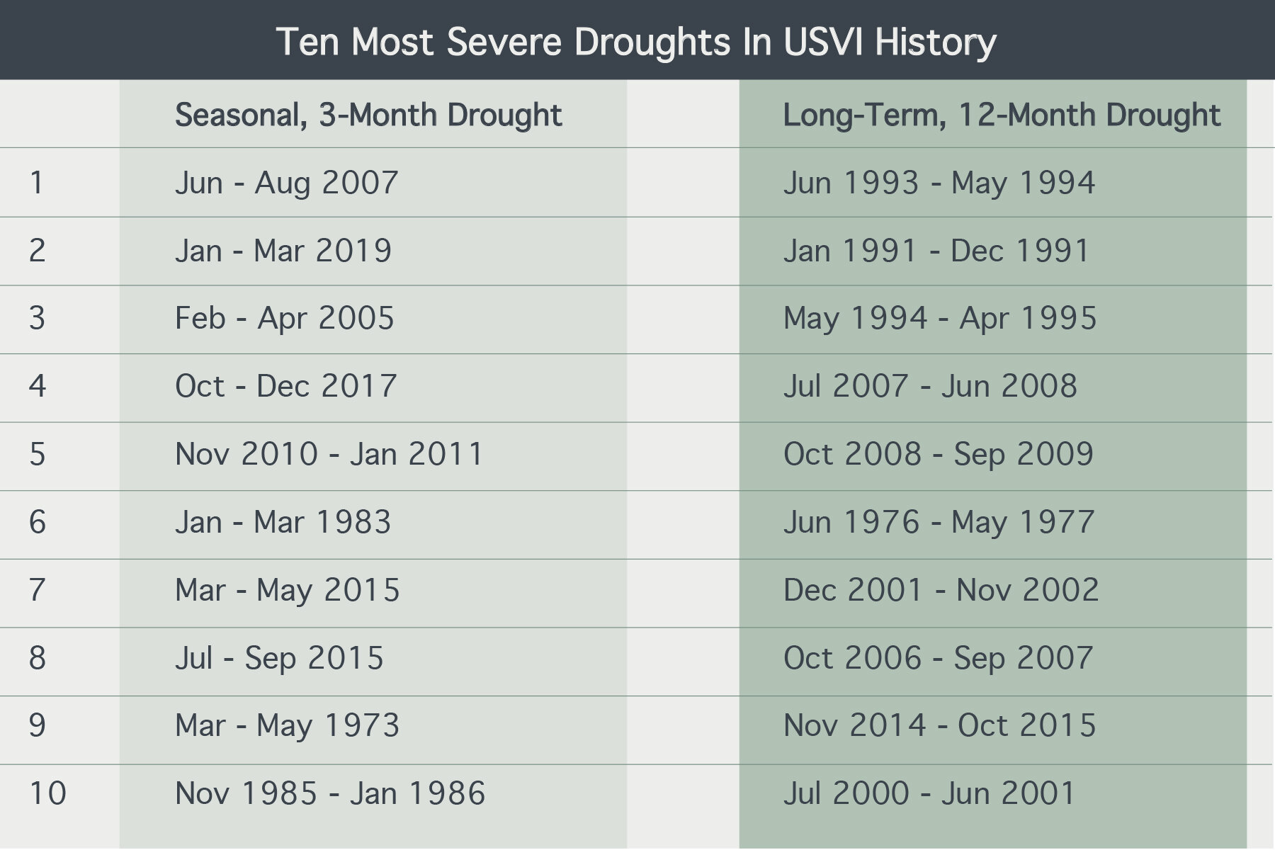
Weather records provide a measure of drought conditions over much of the past 100 years, and especially since the late 1970s. Long-term droughts (12 months or longer) of moderate severity have become more frequent in recent decades. Records from the 1920s – 1980s show moderate drought occurring roughly every 13-14 years. Since 1990, however, the frequency has increased to roughly every four years. Of the 10 most severe long-term droughts on record, none occurred before the 1970s and nine have occurred since 1991 (Table 1, Figure 2).
Seasonal droughts (three months or longer) occur annually in the USVI and are typically experienced as the dry season. The frequency of especially severe seasonal drought has increased dramatically since about 2005 (Table 1, Figure 2). Seven of the eight most severe seasonal droughts on record in the USVI have occurred since 2005.
Table 1. Ten most severe seasonal (3-months) and long-term (12-months) droughts in the USVI. Based on /-3 and SPI-12 calculated at seven long-term weather stations on St. Thomas, St. John, and St. Croix.
Figure 2. Occurrence of the 10 most severe seasonal (3-month) and long-term (12-month) droughts in the USVI by decade.
Types of Drought
There are different ways to think of drought. All drought is caused by a lack of rain over an unusually long period of time. Defining what that means can be difficult and depends on what effects of drought are of concern. Sometimes, it is best to think of drought as the physical lack of rain. Other times, it is better to consider how a lack of rain affects things we care about, such as water availability, the environment, agriculture, the economy, or even human health. Understanding the different ways to think of drought is essential to designing ways to improve our resilience to this hazard.
Meteorological drought describes a physical lack of rain, or dryness, compared with normal, historical conditions. The severity of meteorological drought is measured by comparing recent rainfall, typically the previous month, season, or year, to what has occurred historically. Evaporation also affects the dryness of an area and plays a role in meteorological drought. Evaporation is difficult and expensive to measure compared to rainfall, however, and is usually not considered in measurements of meteorological drought. Meteorological drought is important because it causes all other types of drought and is usually the first indicator that drought is occurring.
Hydrological drought describes how a meteorological drought plays out through the water cycle, especially as it affects the physical availability of water in streams, ponds, reservoirs, and groundwater. These effects take time to develop and are often complex. For example, as a meteorological drought worsens, less water soaks into the ground and flows downward to the underlying groundwater. This allows the upper surface of ground water, called the water table, to fall away from the surface and confirms the growing severity of the drought. A lower water table also reduces, eliminates, or possibly reverses the supply of groundwater to guts (Figure 3), often causing them to run dry.
Figure 3. The Image at left shows groundwater as it flows from the land surface to a nearby stream. At right, a reduction in rainwater infiltrating the surface has lowered the groundwater level. As a result, water now flows out of the stream and becomes groundwater. Image modified from Winter, Thomas C. 1998. Ground water and surface water: a single resource. U.S. Geological Survey (USGS).
Agricultural drought describes how meteorological and hydrological drought affect agriculture. As drought increases in severity, livestock and crops become stressed, reducing yield and increasing vulnerability to other stressors such as disease, predation, and herbivory. In severe cases, crops can fail and livestock can die.
Ecological drought describes the effects of meteorological and hydrological drought on the environment. This type of drought is easy to observe in the USVI when vegetation dries out and the landscape turns brown (Figure 1).
All types of drought affect human well-being. These effects include financial, social, psychological, and health impacts. Understanding how and why drought affects people is critical to improving our resilience to drought.
U.S. Drought Monitor
In June 2019, the USVI was included in the U.S. Drought Monitor. This program provides expert interpretation of drought information and provides maps of current drought conditions across the United States. For the USVI, a group of U.S. Drought Monitor experts from NOAA and several universities monitor and discuss drought conditions, trends in rainfall, temperature, groundwater levels, and even visual observations of drought impacts.
Every two weeks the U.S. Drought Monitor publishes drought severity ratings on their webpage for the three major islands of the USVI (Figure 4). U.S. Drought Monitor ratings combine information on meteorological, hydrological, agricultural, ecological, and even socioeconomic drought. Essentially, the U.S. Drought Monitor provides timely expert interpretation of what drought information means to people.
Figure 4. US Drought Monitor map product for June 2021. Image modified.
The U.S. Drought Monitor provides timely expert interpretation of what drought information means to people.
Drought Prediction
The ability of drought indices and the US Drought Monitor to help recognize and understand developing drought is useful. However, predicting drought months in advance takes this a step further and expands the opportunity for people to anticipate coming droughts and take actions to reduce how they affect our lives.
A Caribbean-wide drought prediction system was launched in 2013. This system essentially combines a three-month rain forecast with recent rain observations. When conditions have been dry in the recent past, and are forecast to be dry in the near future, a high drought probability is forecast. The Caribbean Institute of Meteorology and Hydrology (CIMH), based in Barbados, presently uses this system to produce monthly updates of six-month drought condition forecasts throughout the Caribbean, including for the USVI (Figure 5). CIMH provides these forecasts free of charge on their website and through newsletters. For more information, see http://rcc.cimh.edu.bb/drought-outlook/. The CIMH drought forecasts are already being used intermittently in U.S. Drought Monitor discussions and may develop into an important tool for mitigating the effects of drought.
Figure 5. Example of a drought prediction map available from the Caribbean Institute for Meteorology and Hydrology (CIMH). Image from the Caribbean Regional Climate Center.


